Three days of travel. What better way to break up the drive than with a couple of summits on the way!
Setting out for Ashland, Oregon on a rainy, windy Flagstaff afternoon. Co-pilot is ready!
In Kingman, Arizona, Zoroaster poses for the tourists who just off-loaded from their bus.
Heading into the bright lights of Las Vegas!
#1 Mount Charleston, Nevada (11,918')
Less than an hour from The Strip in Las Vegas sits Mt. Charleston, it's name-sake wilderness area and jaw-dropping views!
Shad Mickelberry joined me for the run.
Looking up the avalanche gully towards the long summit ridge.
Mummy Mountain, Charleston's twin, sits across the valley.
Old bristle cone pine skeletal remnants still stand.
The final approach to the summit cone.
Looking back from where we have come and must return. Looking down at the small town of Mount Charleston and the trailhead location.
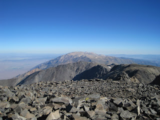
Looking west to Parhump, Nevada and Death Valley beyond from the summit.
The remains of a not-so-lucky helicopter trip.
Looking back along the ridge and the summit cone of Charleston.
Typical ridge line trail.
Zoroaster drinks from one of the few natural sources in the Spring Mountain Range.
#2 White Mountain, California (14,252')
White Mountain is the third highest peak in California. It lays due east of Bishop, CA. You can see the trail/jeep road winding its way up the summit cone and the research station on top.
The 30-mile drive to the trailhead was as much an adventure as the run itself! Can you say lunar landscape?
On the drive in: Overlooking the Patriarch Grove, an ancient bristlecone pine forest (more than 40 centuries old).
Trailhead at Barcroft Gate (11,685')
Frisbee at near 12,000'.
Barcroft Research Station (12,475'). Two miles into the run.
The long jeep road that leads to the summit.
Looking from the summit over to Boundary Peak (Nevada's highest point).
Green agricultural fields in the valley west of the peak.
#3 Black Butte, California (6,334')
Black Butte (an old volcanic cone) looks big, when not dwarfed by its neighbor Mt. Shasta.
The trail near the top gets a little rough.
Views from the circumnavigating trail.
Looking down on I-5 and Castle Crags on the horizon beyond.
Looking down into the caldera.
Looming Mt. Shasta (14,179') makes you feel small, even while sitting on a high mountain like Black Butte.
Moments of Zen...
Coaching Tip: It is important to stay both fueled and...
...hydrated on your long runs!


wow--three beautiful peaks! way to get after it. btw--your dog cracks me up. safe travels!
ReplyDeleteThanks for the fueling and hydrating tips. they made my day.
ReplyDeletehope all's well!
(ran with mer today... she kicked my butt.. again)
Ian,
ReplyDeleteThe real White Mtn Pk T/H is where the pavement turns to dirt on Silver Canyon Rd just above Laws Museum at about 4100' in the Owens Valley. Driving to Barcroft Gate is like getting to start at Duncan Canyon on the States course(which, by the way, would have really helped me to be closer to you at the finish).
And it's a good thing I was in Europe running around Mont Blanc when you came through without getting in touch!...And yes, I would have made you at least start from the Patriarch Grove, store anniversary parties in Ashland to get to or not :)
Later, dude - Kozak
Koz,
ReplyDeleteTo respond in my defense ;>)
Knew you were out of country drinking red wine and eating Freedom fries, Patriarch Grove start line was paved, not an anniversary party, its a Bachelor Party!!!, looked at a Black Canyon-Silver Canyon Loop but decided that I didn't have the panache. Plus I needed all the help I could get after running Chaz the day before, driving the distance on 95 on Corn Nuts alone and running at 14,000'!!! Barcroft Gate became an excellent start line por moi.
Torrence
Ian - Am impressed at Zoroaster's stamina. What are Z's average and longest runs? Would like to get my dog out but doubt she could make it a couple miles right now.
ReplyDeleteYep, the only rpoblem for my trip to Mt. Charleston in April was a snow blizzard turning us back mid-way through the loop, with no trail marking (we already wandered through for hours so far and were on course) and hypothermia. I guess we better make it back:)
ReplyDeleteJay,
ReplyDeleteI'm actually quite impressed with her willingness to continue on-ward with me as well. 24 miles is her farthest. She's a small dog (40lbs.) and a border collie mix. Small paws, small body, efficient stride, good breed. She runs 85% of my runs. When we get back from our runs and I flop on the floor, that's when she think's frisbee or ball-toss is a good idea, she just shoves those toys in my face post-run. Non-stop I tell ya!
Ian
Fair enough Mr. Torrence, fair enough...damn fine mtn., eh? even if it is on dirt road to the summit. ah yes, the HK BP...were all the attendees required to go through a hair check?
ReplyDeleteI love that Mt. Charleston loop- I remember it being surprisingly tough.
And, one more thing...make sure you stay in Flag long enough this time for me to get down there and join you on a double crossing of The Ditch. Last, and only, time I did it was with John Pearch in '03. He had just gotten his MS in Geology and had recently taken a course on the GC. As I remember it we gauged the rate of ascent/descent on each leg by how much time passed between his rattling off the names of each rock layer. On the final climb back out to the South Rim he probably could have read his entire textbook to me.
-Koz
Very cool. Great zen pics. ;)
ReplyDelete